Initially copy editing appealed to the logic part of my brain — the part that likes math and programming (until the other side of my brain gets annoyed). But as an editor it’s important to accept the fact that rules are more fluid than static. The number one rule is consistency in your publication. Stylebooks say things like: always this, but this and this in this or this case.
All that is preface to why the L.A. Times would bother with the daunting task of mapping the neighborhoods of Los Angeles. The inconsistencies that would crop up in Times stories were enough to make editors, and other Angelenos, grind their teeth at night.
Without further ado: L.A.’s *official* neighborhoods (according to the L.A. Times and reader comments on their site):
Central Region: Chinatown, Downtown, Echo Park, Elysian Park, Elysian Valley, Fairfax, Griffith Park, Hancock Park, Hollywood, Hollywood Hills, Hollywood Hills West, Koreatown, Los Feliz, Mid-City, Pico-Union, Silver Lake, Westlake
Harbor Region: Harbor Gateway, San Pedro, Wilmington
Northeast Region: Atwater Village, Cypress Park, Eagle Rock, Glassell Park, Highland Park, Montecito Heights, Mount Washington
South Region: Crenshaw, Exposition Park, Historic South-Central Los Angeles, Hyde Park, Jefferson Park, Leimert Park, South Los Angeles, South Park, University Park, Watts, West Adams
The Eastside: Boyle Heights, El Sereno, Lincoln Heights
The Valley: Arleta, Canoga Park, Chatsworth, Encino, Granada Hills, Lake View Terrace, Mission Hills, North Hills, North Hollywood, Northridge, Pacoima, Panorama City, Porter Ranch, Reseda, Shadow Hills, Sherman Oaks, Studio City, Sun Valley, Sunland, Sylmar, Tarzana, Toluca Lake, Tujunga, Valley Glen, Valley Village, Van Nuys, West Hills, Winnetka, Woodland Hills
The Westside: Bel-Air, Beverly Glen, Beverlywood, Brentwood, Cheviot Hills, Del Rey, Mar Vista, Pacific Palisades, Palms, Pico-Robertson, Playa Vista, Playa del Rey, Sawtelle, Venice, West Los Angeles, Westchester, Westwood
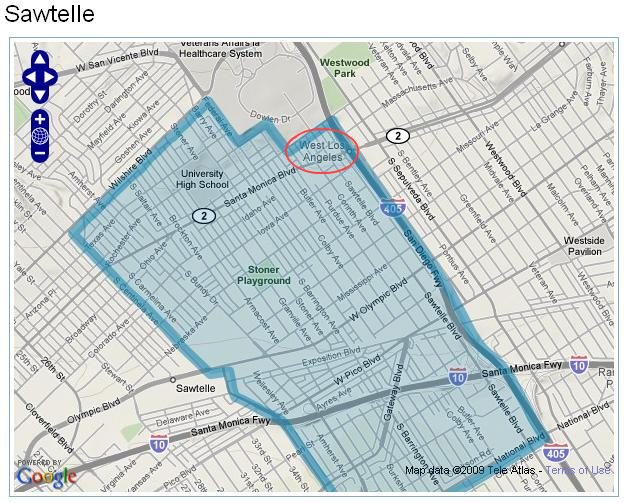
Some of the neighborhood designations are more questionable than others. For, example the above neighborhood — “Sawtelle” — designated as separate from West L.A. — actually says “West Los Angeles” on the Google Maps image. When I lived there it was “West Los Angeles,” and I’ve never heard it referred to otherwise (except maybe the area on Sawtelle Blvd.) so finding it dubbed “Sawtelle” was a surprise. According to the comments on the page: “This area is West L.A. Sawtelle is a street,” and “If you decide to call this neighborhood ‘Sawtelle,’ you’ll be giving it that name. You won’t be tracking customary usage.”
I’m sure there are other instances like this on the L.A. Times map. It’s a tough job… Designating neighborhoods is like designating emotions: If there’s a boundary between frustration and anger, it’s sometimes vague; and sometimes you can’t even name what you’re feeling. You could dub something “angstration” or “Beverlywood,” but that doesn’t mean other people will know what you’re talking about or grant that it exists. Sometimes it’s best to just not label things, especially if you haven’t lived there. (Of course then we’re left with journalistic inconsistency and subjectivity, and what kind of world is that!?)


i think, eventually, neighborhoods will be known only by their corporate, big box chain names. targetwood, costco village, etc. costco and bed, bath and beyond already have their own named streets that lead into their parking lots. left unchecked, it will happen.
it’s already happened to all the stadiums. this threat is for real.
this seems quite possible. maybe if we’re lucky, we’ll get a celebrity / benefactor name attached too: John Wayne Targetwood, Eli Broad Contemporary Costco Park, etc.